
Happy 80th Birthday to the Sydney Harbour Bridge
Official name Sydney Harbour Bridge
Carries Trains, Motor vehicles, pedestrians and bicycles
Crosses Port Jackson
Locale Sydney, Australia
Design Through arch bridge
Total length 1,149 m (3,770 ft)
Width 49 m (161 ft)
Height 134 m (440 ft)
Longest span 503 m (1,650 ft)
Clearance below 49 m (161 ft) at mid-span
Construction begin 28 July 1923
Construction end 19 January 1932
Opened 19 March 1932
Coordinates 33°51′08″S151°12′38″E
The Sydney
Harbour Bridge is a steel through
arch bridge across Sydney Harbour that
carries rail, vehicular, bicycle and pedestrian traffic between the Sydney central business district (CBD) and the North Shore.
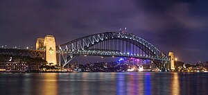
The dramatic view of the bridge, the harbour, and the nearby
Sydney Opera House is an iconic image of both Sydney and Australia.
The bridge is nicknamed "The Coat hanger"
because of its arch-based design.
Under
the directions of Dr J.J.C. Bradfield of the NSW
Department of Public Works, the bridge was designed and built by British firm Dorman Long and Co Ltd of Middlesbrough (who based the design on their 1928 Tyne
Bridge in Newcastle upon Tyne) and opened in 1932.
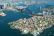
Sydney Harbour from the
air, showing the Opera House, the CBD, Circular Quay, the Bridge, the
Parramatta River, North Sydney and Kirribilli in the foreground
According to the Guinness
World Records, it is the world's widest long-span bridge. It is also the fifth longest spanning-arch
bridge in the world, and it is the tallest steel arch bridge, measuring 134
metres (440 ft) from top to water level.
Until 1967 the Harbour Bridge was Sydney's tallest structure.
An estimated 469 buildings on
the north shore, both private homes and commercial operations, were demolished
in order to allow construction to proceed, with little or no compensation being
paid. Work on the bridge itself commenced with the construction of approaches
and approach spans, and by September 1926 concrete piers to support the
approach spans were in place on each side of the harbour.

The south-eastern pylon
containing the tourist lookout,. Both pylons were made of granite quarried at Moruya, NSW
As construction of the
approaches took place, work was also started on preparing the foundations required to support the enormous weight of
the arch and loadings. Concrete and granite faced abutment towers were
constructed, with the angled foundations built into their sides

Sydney Harbour Bridge under
construction
Once work had progressed
sufficiently on the support structures, a giant' creeper crane' was erected on
each side of the harbour.

The arch being constructed.
Courtesy, State Library of New
South Wales
Once the arch was completed,
the creeper cranes were then worked back down the arches, allowing the roadway
and other parts of the bridge to be constructed from the centre out. The
vertical hangers were attached to
the arch, and these were then joined with horizontal crossbeams. The deck for
the roadway and railway were built on top of the crossbeams, with the deck
itself being completed by June 1931, and the creeper cranes were dismantled.
Rails for trains and trams were laid, and road was surfaced using concrete
topped with asphalt. Power and telephone lines, and water, gas, and
drainage pipes were also all added to the bridge in 1931.
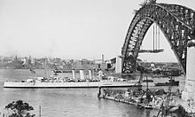
HMAS Canberra sailing
under the completed arch from which the deck is being suspended in 1930
The roadway of the bridge, (below)
from the southern or city approach. From left: walkway, eight traffic lanes
(the two leftmost once carried the Sydney
trams), two railway tracks, and cycleway. The
gantries with lights controlling traffic tidal flow are clearly visible, while
the tollbooths can be seen near the bases of the high-rise buildings.

A popular tourist attraction, you can
climb the bridge on organised tours. All climbers are required to wear a
special ‘jump suit’ and are provided with protective clothing appropriate to the
prevailing weather conditions and are given an orientation briefing before
climbing. During the climb, attendees are secured to the bridge by a wire
lifeline. Each climb begins on the eastern side of the bridge and ascends to
the top. At the summit, the group crosses to the western side of the arch for
the descent. Each climb is a three-and-a-half-hour experience.

Bridge Climb participants, wearing the mandatory special jumpsuits
In December 2006, Bridge Climb launched
an alternative to climbing the upper arches of the bridge. The Discovery Climb
allows climbers to ascend the lower chord of the bridge and view its internal
structure. From the apex of the lower chord, climbers ascend a staircase to a
platform at the summit.

Bridge Climbers admire the
view mid-climb, while a second group reach the top of the arch.
3 comments:
thanks! my daughter is studying engineering in college and learning to build bridges....she LOVES this stuff!!
Lady Magnon will be there in a week; she loves the bridge, but mostly she loves the ferries.
It's a beautiful structure and the Blue Granite for the pylons is amongst the hardest granite in the world and was quarried at Moruya (on the coast and not far from here) and ferried up the coast on barges. I did my 'Industrial Archeology' study at the old quarry and wharves on the Moruya River.
Post a Comment